About All Tours From Surabaya ToursSunrise ToursFrom Malang ToursFrom Yogyakarta ToursAnd Ijen ToursFrom Surabaya Tours3-Day Ijen Crater ToursIjen From Bali Tours Directions Hours & Fees
Find Tours 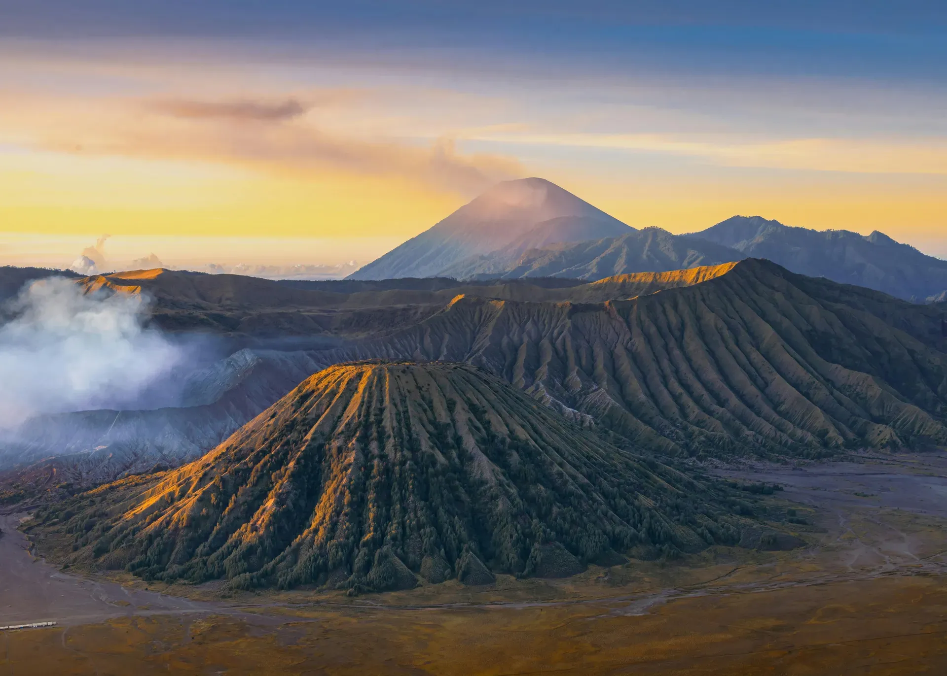
Mount Bromo is an active somma volcano rising 2,329 meters from a 10-kilometer-wide caldera in East Java, Indonesia. It anchors a vast plain of grey volcanic ash known as the Sea of Sand.
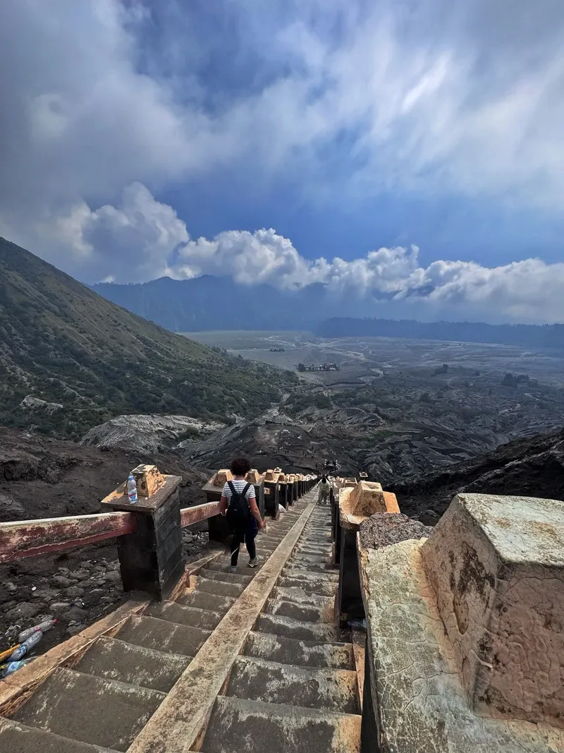
Mount Bromo rises 2,329 meters above sea level inside the 10-kilometer-wide Tengger Caldera in East Java, Indonesia. It is an active somma volcano, meaning its current cone formed within the collapsed crater of an older, larger mountain. A 10-square-kilometer desert of grey volcanic ash, called the Sea of Sand (Lautan Pasir), surrounds the peak. Visitors cross this barren expanse by 4WD jeep, dirt bike, or on horseback before climbing 250 concrete steps to reach the smoking crater rim. The smell of sulfur hits the air miles before the base, growing stronger as the elevation increases.
Temperatures at the Penanjakan 1 viewpoint drop to 5°C before dawn. Crowds gather here around 04:00 to watch the sun illuminate the caldera, with the highly active Mount Semeru venting ash in the background. By mid-morning, the temperature on the sand sea climbs to 25°C. Fine volcanic dust hangs in the air, requiring a high-quality face mask to filter out the particulate matter and sulfur fumes. The dust coats clothing and camera lenses within minutes of stepping out of a vehicle.
Accessing the mountain requires navigating a specific route through gateway villages. Most travelers arrive via Cemoro Lawang, a settlement perched directly on the northeastern edge of the caldera drop-off. The descent from the village to the sand sea involves a steep, narrow paved road that only authorized jeeps and local motorcycles can navigate safely. Private cars must park in the upper village lots.
Conditions change rapidly based on seismic activity. The Center for Volcanology and Geological Hazard Mitigation (PVMBG) monitors the vent daily using seismographs and visual observation posts. During periods of increased unrest, authorities enforce a 2.5-kilometer exclusion zone, cutting off access to the crater steps entirely. Heavy rains in January and February turn the Sea of Sand into a waterlogged mud pit, frequently trapping jeeps up to their axles. Tickets cost 255,000 IDR for foreigners and must be purchased online at least 48 hours before arrival through the official park portal.
The Tengger Caldera formed approximately 820,000 years ago when a massive ancient stratovolcano, reaching an estimated 4,500 meters in height, collapsed in on itself following a catastrophic eruption. Mount Bromo emerged later as a new cone growing from the floor of this depression, alongside neighboring peaks like Mount Batok and Mount Kursi. It takes its name from Brahma, the Hindu creator god. Records show over 60 distinct eruptions since 1767. These events routinely reshape the crater rim and deposit fresh layers of grey ash across the surrounding 10-square-kilometer plain.
Human settlement around the volcano traces back to the 15th century. Princess Roro Anteng and Joko Seger fled the declining Majapahit Empire and established the Tenggerese tribe in these remote highlands. According to local records, the couple remained childless for years before meditating on Bromo's slopes. The gods granted them 25 children on the condition that the youngest, Prince Kesuma, be sacrificed to the crater. This event established the foundation for the region's religious practices and the annual pilgrimage to the rim.
Major eruptions in the 21st century repeatedly disrupted local life and international travel. A prolonged eruptive phase from late 2010 into early 2011 sent ash plumes 2,000 meters into the sky, forcing the closure of domestic airports in Malang and Probolinggo. Heavy ashfall destroyed hectares of cabbage and potato crops in the surrounding high-altitude farming villages. Another significant eruption in 2015 produced a constant roar audible from Cemoro Lawang, raining lapilli (volcanic gravel) onto the Sea of Sand and stripping the vegetation from the nearby hillsides.
Tourism infrastructure expanded significantly in the late 20th century to accommodate growing international interest. The Indonesian government established the Bromo Tengger Semeru National Park in 1982, protecting 50,276 hectares of land. Paved roads eventually reached the gateway village of Cemoro Lawang, cutting the travel time from Surabaya to three hours via the toll route. Concrete steps were poured directly into the volcanic cone to facilitate access to the 800-meter-wide crater rim.
The 2020s brought stricter management to the site. Following the December 13, 2023 eruption, park officials tightened access protocols. On-site ticket sales ended entirely in late 2024 to control daily visitor quotas. Travelers now navigate a mandatory online booking system, and commercial photographers must secure a 5,000,000 IDR permit before operating drones or professional equipment within the caldera boundaries.
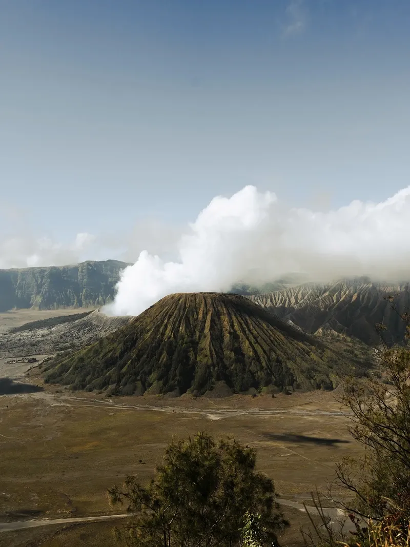
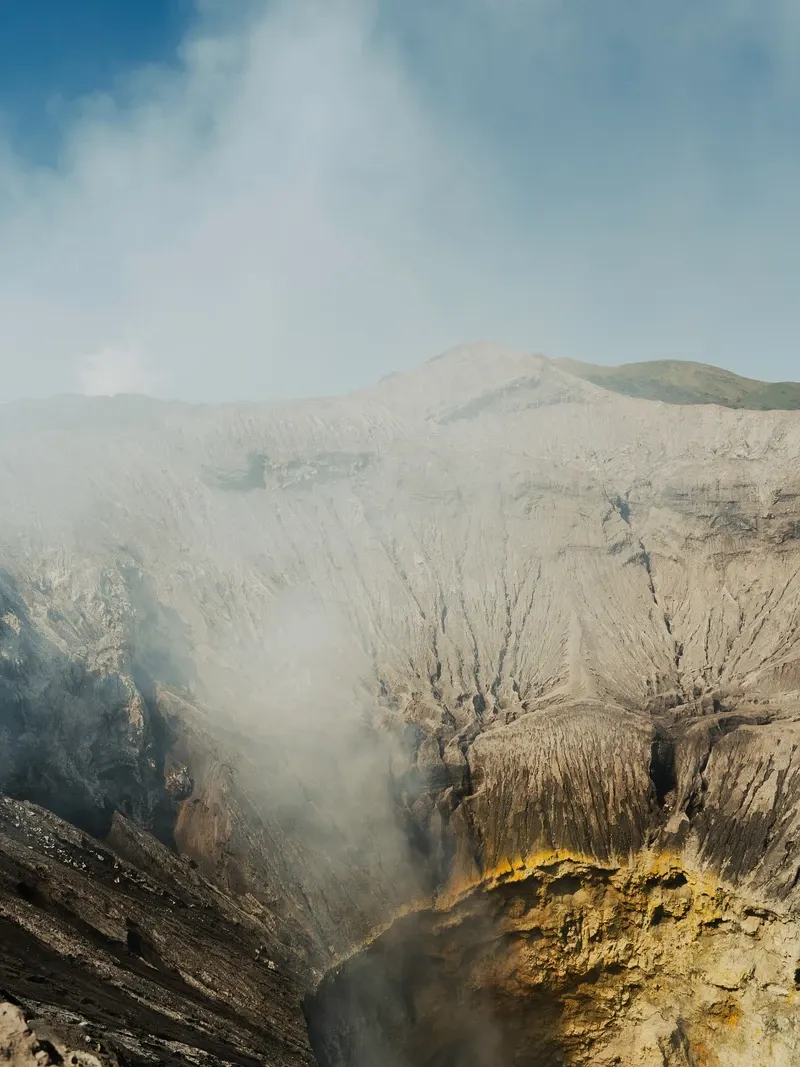
Mount Bromo stands 2,329 meters above sea level, but it is not the highest peak in the Tengger massif. It is simply the most active. The crater measures 800 meters from north to south and 600 meters from east to west. A constant plume of white sulfurous gas rises from the central vent, sometimes turning grey or brown depending on the magma movement below. The rim consists of loose, grey volcanic scree and hardened lava bombs from past eruptions. A narrow, fenced path allows visitors to walk along the edge, looking directly down into the smoking caldera where the sheer interior walls drop hundreds of feet to the active vent.
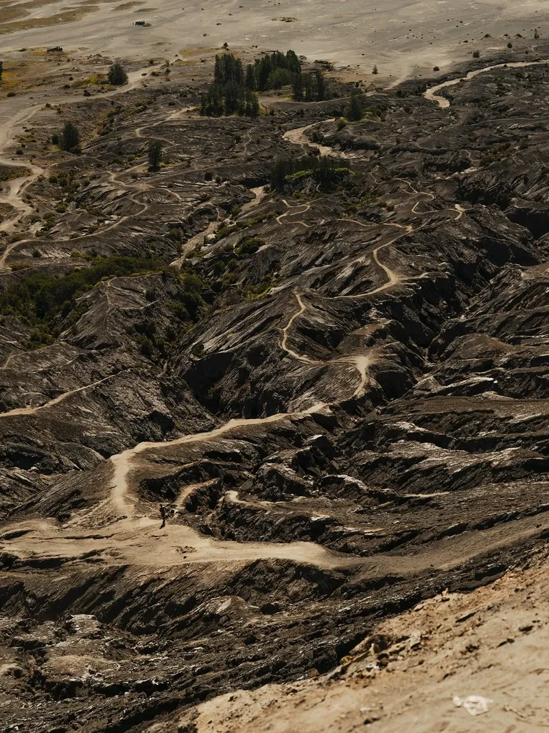
The Sea of Sand (Lautan Pasir) isolates the volcano from the surrounding caldera walls. This 10-square-kilometer expanse consists entirely of fine volcanic ash, pumice, and sand deposited by centuries of eruptions. Wind sweeps across the dunes in the eastern section, creating a distinct whistling noise that locals call the Whispering Sands. The terrain contains almost no vegetation, resembling a lunar landscape rather than a tropical island. Deep ravines cut through the ash plain where seasonal rainwater channels away from the central cone.
Immediately adjacent to Bromo sits Mount Batok, a dormant cinder cone reaching 2,440 meters. Unlike Bromo's barren grey slopes, Batok is heavily fluted with deep erosion gullies and covered in sparse green vegetation. The contrast between the smoking, ruined crater of Bromo and the perfectly symmetrical, ribbed cone of Batok provides the classic foreground for photographs taken from the northern viewpoints.
Contrasting sharply with the barren ash plain, the southern side of the massif features Teletubbies Hill. This undulating savanna is covered in dense green grass and ferns during the dry season from April to October. The transition from grey desert to green hills happens abruptly over a distance of just a few kilometers. Jeeps navigating the sand sea frequently get stuck in deep ash drifts near this transition zone. Drivers carry shovels and tow ropes to dig out trapped vehicles before the afternoon fog rolls into the basin.
The Tenggerese people practice a distinct form of Hinduism that incorporates ancient Javanese animist traditions and centers entirely on Mount Bromo. They consider the volcano a sacred site rather than just a geological feature. Pura Luhur Poten, a Hindu temple constructed from black volcanic stone, sits directly on the floor of the caldera at the base of the mountain. The architecture mimics traditional Balinese temples but utilizes the harsh, dark materials of the surrounding sand sea. The temple remains closed to tourists, functioning solely as a place of worship for the local population and a staging ground for religious ceremonies.
Every year, the community holds the Yadnya Kasada festival on the 14th day of the Kasada month in the traditional Hindu lunar calendar. Thousands of Tenggerese walk across the Sea of Sand at midnight, led by local shamans known as dukuns. They climb the 250 concrete steps to the crater rim and throw offerings into the smoking vent. These offerings include rice, fruit, vegetables, money, and live livestock like goats and chickens. The ritual honors the legendary sacrifice of Prince Kesuma and seeks blessings for agricultural yields in the coming year.
The physical act of the offering involves significant risk. During the festival, some locals climb down onto the steep, unstable inner slopes of the crater. They stand precariously above the active vent with nets to catch the thrown offerings before they fall into the sulfurous depths. They believe catching these items brings personal luck and prosperity, despite the danger of inhaling toxic gas or sliding into the crater.
Visitors attending during Yadnya Kasada face severe restrictions. The park often closes to regular tourism to prioritize the religious procession and maintain the sanctity of the ritual. Drones are strictly banned during the ceremony to avoid disrupting the prayers and the concentration of the dukuns. Travelers planning a trip around this time should check the local lunar calendar, as the exact festival date shifts annually between June and August.
The Tengger Caldera contains five distinct volcanoes: Bromo, Batok, Kursi, Watangan, and Widodaren.
The eastern section of the caldera produces a high-pitched whistling sound when wind blows across the dunes.
Single-use plastics, including bottles and straws, are completely banned within the national park boundaries.
Pura Luhur Poten, the temple at Bromo's base, is built entirely from black volcanic stones gathered from the surrounding sand sea.
Foreigners must pay a 5,000,000 IDR permit fee to conduct commercial photography or fly a drone inside the park.
During the Yadnya Kasada festival, some locals stand on the steep inner slopes of the crater to catch livestock thrown as offerings.
Temperatures at the sunrise viewpoints routinely drop to 0°C, despite the volcano's location in tropical Indonesia.
Mount Bromo is an active somma volcano located inside the Tengger Caldera in East Java, Indonesia. It stands 2,329 meters tall and is surrounded by a 10-square-kilometer plain of volcanic ash called the Sea of Sand.
Foreign tourists pay a flat entrance fee of 255,000 IDR for both weekdays and holidays. Tickets must be purchased online at least 48 hours in advance through the official park website.
Jeep tours typically depart from Malang or Cemoro Lawang between 02:00 and 03:00. Visitors need to reach the Penanjakan 1 viewpoint by 04:00 to secure a spot before the sun rises around 05:30.
There are 250 concrete steps leading from the base of the volcanic cone to the crater rim. The climb takes most visitors 15 to 20 minutes depending on altitude acclimatization.
The volcano is closely monitored by Indonesian authorities. During periods of high seismic activity or toxic gas release, officials enforce a 2.5-kilometer exclusion zone that blocks access to the crater.
The Sea of Sand (Lautan Pasir) is a barren, 10-square-kilometer desert of fine volcanic ash surrounding Mount Bromo. Visitors cross this plain using 4WD jeeps, dirt bikes, or horses to reach the base of the volcano.
The dry season from April to October offers the clearest skies for sunrise views. January and February bring heavy monsoon rains that turn the Sea of Sand into deep mud and obscure the caldera in fog.
Temperatures at the sunrise viewpoints drop to between 0°C and 5°C before dawn. You need a winter jacket, gloves, and a beanie, along with a high-quality face mask to block sulfur fumes and volcanic dust.
You can take a two-hour train from Surabaya Gubeng to Probolinggo, followed by a two-hour local minibus ride to Cemoro Lawang. Alternatively, a direct private car via the toll road takes three to four hours.
Yadnya Kasada is an annual Hindu ritual where the indigenous Tenggerese people throw agricultural products and livestock into the Bromo crater. It occurs on the 14th day of the Kasada month in the traditional lunar calendar.
Browse verified tours with free cancellation and instant confirmation.
Find Tours